Raster Analyses
Available Spatial Packages
spFirst major spatial data package/formatrgdalreading and writing spatial datargeosInterface to open-source geometry engine (GEOS)sfSpatial Features in the ‘tidyverse’rastergridded data (like satellite imagery)- and a few others…
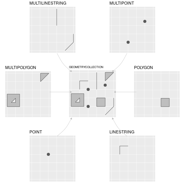
Common Simple Feature (SF) types

What about grids?

Raster Data
Raster Data Types
Many types including:
- Thematic (classified/thematic) data: land-use or soils data.
- Continuous data (temperature, elevation, spectral)
- Imagery / Pictures (scanned maps, drawings, etc.)
Most Common:
- Satellite Imagery and derived products
- Earth System Models (e.g. climate models)
- Other models
Raster data in the tidyverse
Raster data is not yet closely connected to the tidyverse, however:
- Some functions from
rasterwork well inpipes - Convert vector data to
Spatial*form usingas(my_vector, "Spatial")for raster-vector interactions - Some early efforts to bring raster data into the tidyverse, including tabularaster, sfraster, fasterize, and stars (multidimensional, large datasets).
Raster Package
library(raster)
library(spData)
data(elev) #load fake data from spData package
plot(elev) #load fake data from spData package
Raster Data Structure
## class       : RasterLayer
## dimensions  : 6, 6, 36  (nrow, ncol, ncell)
## resolution  : 0.5, 0.5  (x, y)
## extent      : -1.5, 1.5, -1.5, 1.5  (xmin, xmax, ymin, ymax)
## coord. ref. : +proj=longlat +datum=WGS84 +ellps=WGS84 +towgs84=0,0,0
## data source : in memory
## names       : layer
## values : 1, 36 (min, max)## Formal class 'RasterLayer' [package "raster"] with 12 slots
## ..@ file :Formal class '.RasterFile' [package "raster"] with 13 slots
## .. .. ..@ name : chr ""
## .. .. ..@ datanotation: chr "FLT4S"
## .. .. ..@ byteorder : chr "little"
## .. .. ..@ nodatavalue : num -Inf
## .. .. ..@ NAchanged : logi FALSE
## .. .. ..@ nbands : int 1
## .. .. ..@ bandorder : chr "BIL"
## .. .. ..@ offset : int 0
## .. .. ..@ toptobottom : logi TRUE
## .. .. ..@ blockrows : int 0
## .. .. ..@ blockcols : int 0
## .. .. ..@ driver : chr ""
## .. .. ..@ open : logi FALSE
## ..@ data :Formal class '.SingleLayerData' [package "raster"] with 13 slots
## .. .. ..@ values : int [1:36] 1 2 3 4 5 6 7 8 9 10 ...
## .. .. ..@ offset : num 0
## .. .. ..@ gain : num 1
## .. .. ..@ inmemory : logi TRUE
## .. .. ..@ fromdisk : logi FALSE
## .. .. ..@ isfactor : logi FALSE
## .. .. ..@ attributes: list()
## .. .. ..@ haveminmax: logi TRUE
## .. .. ..@ min : int 1
## .. .. ..@ max : int 36
## .. .. ..@ band : int 1
## .. .. ..@ unit : chr ""
## .. .. ..@ names : chr ""
## ..@ legend :Formal class '.RasterLegend' [package "raster"] with 5 slots
## .. .. ..@ type : chr(0)
## .. .. ..@ values : logi(0)
## .. .. ..@ color : logi(0)
## .. .. ..@ names : logi(0)
## .. .. ..@ colortable: logi(0)
## ..@ title : chr(0)
## ..@ extent :Formal class 'Extent' [package "raster"] with 4 slots
## .. .. ..@ xmin: num -1.5
## .. .. ..@ xmax: num 1.5
## .. .. ..@ ymin: num -1.5
## .. .. ..@ ymax: num 1.5
## ..@ rotated : logi FALSE
## ..@ rotation:Formal class '.Rotation' [package "raster"] with 2 slots
## .. .. ..@ geotrans: num(0)
## .. .. ..@ transfun:function ()
## ..@ ncols : int 6
## ..@ nrows : int 6
## ..@ crs :Formal class 'CRS' [package "sp"] with 1 slot
## .. .. ..@ projargs: chr "+proj=longlat +datum=WGS84 +ellps=WGS84 +towgs84=0,0,0"
## ..@ history : list()
## ..@ z : list()Arrays with metadata
## , , 1
##
##      [,1] [,2] [,3] [,4] [,5] [,6]
## [1,]    1    2    3    4    5    6
## [2,]    7    8    9   10   11   12
## [3,]   13   14   15   16   17   18
## [4,]   19   20   21   22   23   24
## [5,]   25   26   27   28   29   30
## [6,]   31   32   33   34   35   36
Rasters are just arrays / matricies with metadata.
Cell Stats
## [1] 18.5## 0% 25% 50% 75% 100%
## 1.00 9.75 18.50 27.25 36.00Raster Data Memory
## [1] TRUE## [1] TRUERaster does not try to load or work with large datasets in RAM. It creates temporary files and processes them in the background.
Map Algebra
Convert feet to meters

Simple Filter

Focal
##      [,1] [,2] [,3]
## [1,]    1    1    1
## [2,]    1    1    1
## [3,]    1    1    1
Arbitrary functions

Distances to non-NA cells

Distance unit is meters if RasterLayer is +proj=longlat, map units (typically also meters) otherwise.
And much more
- aggregate (to coarser resolution)
- area (calculate cell area)
- buffer
- contour
- crop
- interpolate
- Moran’s I
Visualization
ggplot

All ggplot functionality available
